Three of us – Anand, Manish and I left Pune in Maruti-800 on the night of 24th April at around 11:30 pm. The road to Neral – the town at base of Matheran/Peb fort - is quite a peaceful drive. Get off the expressway at Khopoli exit and head toward Mumbai along the old Mumbai-Pune highway. After about 16 km you come to ‘Chowk phata’ from where you need to take a right onto a road to Karjat. About 7 Km from there and 2 km before Karjat, you come to a junction from where the road to left heads to Neral, Badalapur. Neral is about 14 km from this junction.
 Alternatively you can take a train to Karjat and then board a local train to Mumbai and get down at Neral station which falls on Pune –Mumbai railway line. You can spend the night at Neral station. The station area gets pretty busy from 5:30 am onwards and there are plenty of places serving hot tea and breakfast. So you can start your day early
We reached Neral at around 2:30 am and parked our car on the outskirts of Neral just off the highway that heads to Badalapur. We slept in the car. We hardly got any sleep because of the humid and warm climate. We got up at 5:45 am and drove to the station which was about 1 to 1.5 km or so from where we had parked. After our morning tea and breakfast we drove back to Badalapur road parked our car at one of the dhaba’s/hotel off the highway but adjacent to Jeejamata Bhosale Talao. You can clearly see Peb fort and Matheran towards west from almost anywhere in Neral. Peb (also called Vikatgad), lies to immediate north of Matheran. The talao (lake) lies to the east of the road, but a bit away from it. Start walking north along the highway from there and within 200 ft the trail to Peb fort springs off toward west. Within next couple of minutes you would find crossing a wall of a small dam.
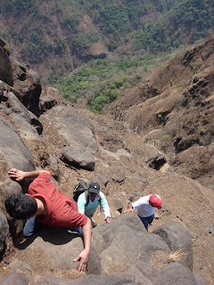
 We started walking toward Peb at about 7:30 am. It was getting pretty hot early in the morning itself, but the dry clouds in the sky decided to have mercy on us and covered us with their shadow till we reached almost to the top Peb fort. First 15-20 minutes of walk is along the ground level and then the climb starts. Most of the trail follows the high tension power line. So watch for the power line towers. Within an hour or so we reached to the top of the ridge that lies immediately to north of Peb (Vikatgad). Some call this as ‘panorama point’ from where you can see what lies to the west of Peb fort. The tower line climbs down to the other side of the ridge but the trail turns south and climbs up along the ridge that connects to Peb fort. We stopped here for 10 minutes, took some snaps of the fantastic view. Within next 10 minutes you will encounter a 15-20 ft tall rock patch after which the trail hugs the western face of Peb fort, with the mountain face on your left and valley on your right. Within next 5 minutes you reach a lovely cave called ‘Samartha Guha’. This surely is a great spot to spend the night if you are up for staying on the top. A couple of minutes before this cave you will come across a small cave opening on your left. You need to crawl on your knees for about 10 – 15 feet to reach a small water reservoir inside. You surely need a torch here because its pitch dark in here. But the water in here is clean and cold and absolutely drinkable.
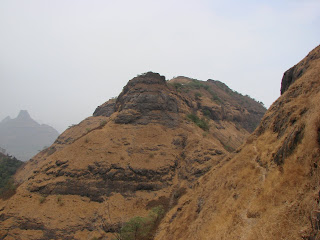 From the Samarth cave the road takes you to a 20-30 ft tall iron ladder. Climb that one and follow the trail that takes you south in the direction of Matheran and then turns north again climbs to top of the fort. The top face is pretty narrow. The view from here is lovely. You can see Matheran to the south. Prabalgad toward south-west and Kalavantini-durg to immediate north of Prabalgad as if it is attached partially to Prabalgad. You see the expressway to the west. To your north-west you see Chanderi and Haji-Malang. We spent a few moments here and then headed down toward Shiv-temple. We were hungry by that time and had some food. We then headed south to Matheran.
The trail from the temple would take you to a steep iron staircase/ladder about 40-50 ft deep and fixed to the rock beneath and the rock walls on the side. Getting down this one is quite a thrill. From here on the trail to matheran is quite peaceful. Within 20-25 minutes it will connect you to the Neral station - Matheran toy train track. From here on you have to walk along the track to Matheran. The track would take you through patches of open and wooded areas and then finally enter into densely wooded region of Matheran.
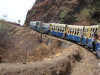 We reached Matheran at around 1:00 – 1:15 pm, walked a little in the market area, had lunch and then took the 2:45 pm train to Neral. The train takes around 2 hours. We reached Neral station at 4:45 pm, walked to our car, had tea and then took off to Pune and reached home for dinner.
During summer or winter, if you plan your hike early morning, you can have breakfast near Neral station and reach Matheran in time for lunch. So you can leave your cooking gear at home. In monsoon though it would take more time to reach Matheran.
More photos of Peb-Matheran
Authored by: Mandar Garge